Publication select ▼

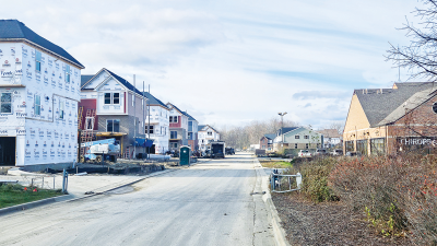
SOUTHFIELD — If all goes the way some hope, there could be exciting additions coming to some communities in Oakland County.
In July, the Oakland County Parks and Recreation Commission was awarded a $45,000 Planning and Assistance Program grant by the Southeast Michigan Council of Governments to fund a feasibility study to determine how Nine Mile Road corridor communities, located between Hazel Park and the city of Farmington, can collaborate to share resources and connect cities with almost 17 miles of continuous nonmotorized pathways.
The study is known as the Nine Mile Corridor Feasibility Study.
Aside from Farmington and Hazel Park, the other cities involved in the study are Farmington Hills, Ferndale, Southfield and Oak Park.
According to a resolution that was adopted by Farmington’s City Council at a regular meeting Oct. 3, the study seeks to bolster recreational opportunities and placemaking along the corridor by creating or improving safe and equitable transportation options along the corridor, establishing and promoting connections to different city assets, coordinating green infrastructure standards, and establishing cohesive corridor branding and wayfinding systems that facilitate mobility and recreation.
Nine Mile Road is a major east-west connector in southern Oakland County, with the cities involved in the study having a vested interest.
For Southfield, this initiative has already been in the works internally.
“Well, I’m always happy to talk about this, because we’ve accomplished a lot,” Southfield Mayor Ken Siver said. “But it’s important that I give you some history first. Southfield was a ‘boom town’ post World War II, with substantial growth in the ’50s and ’60s. For a number of years, Southfield was Michigan’s fastest-growing city, and it was built around the automobile. The neighborhoods were planned without sidewalks; it was all about moving traffic along as quickly as possible. So, you have this dominated design that isn’t really pedestrian friendly.”
He explained that as time has progressed, there’s been a shift in the city’s mindset. People desire more walkable spaces leading Southfield to set their eyes on making the city “more pedestrian friendly.”
Siver stated that for the past decade, the city has essentially been undoing what was done in the ’50s and ’60s, focusing on adding more sidewalks, trails and pathways. This is all part of the complete streets project, which includes adding more benches, trash cans, landscaping, trees, public art installations, wayfinding signage and “all these kinds of things that encourage walking.”
An example of this expansion is the trail that starts at 11 Mile and Lahser Road, extending through both sides of Northwestern Highway, roughly 8.5 miles to Cornell Road, which eventually will connect to Northland Center. In recognition of the estimated 20 miles of pathways Southfield has generated over the last 10 years, AARP’s “Age-Friendly Community” designation was awarded to the city.
Melissa Prowse is the manager of planning and development for the Oakland County Parks and Recreation Commission. From her perspective, these types of projects are popular with residents.
“As the county recreation agency, the No. 1 thing that we hear from residents of the county is that they want more trails and pathways — it’s No. 1 in every study that we do,” she said. “It’s the thing that people are most passionate about, not only for exercise and recreation, but for commuting and getting to places around their communities. So for us, this was a really nice way to play a role in that.”
One aspect of the study is to help determine the best locations and types of trails and greenways for the corridor.
According to the SEMCOG Planning Assistance Program Application that was submitted by the Oakland County Parks and Recreation Commission, the project would connect and expand the network of walking and biking infrastructure in the region. Part of the information submitted on the application also states the following:
“The Nine Mile corridor runs through several moderate and high demand communities, identified as those likely to be the most bicycle and pedestrian friendly parts of the region or with the most potential to support more people walking and biking. The project aligns with the guiding principles of the 2045 Regional Transportation Plan, including connecting people safely to jobs and essential services, stewarding environmental and cultural resources, promoting coordinated and effective public services, and engaging with local leaders and residents.”
The study includes five phases. Phase III was set to begin in November and run through February 2023, and it includes the creation of the overall vision for the Nine Mile pathway by combining the existing conditions analysis with results from the public engagement process. Phase IV is from February to April and is expected to include the development of an implementation plan for identified projects that will include partners, an implementation timeframe, prioritization and potential funding sources. Phase V, which is set to be from May to June, is expected to finalize the feasibility study and provide it to stakeholder communities for review and approval.
Phase V is also expected to include a report that will provide a unified approach to the coordination of the Nine Mile corridor between task force communities, with the creation of a framework for communities to work together to implement improvements.
According to wording submitted on the application, the project has the potential to connect residents with a variety of amenities and necessities.
“Along the Nine Mile corridor, there are several parks, such as (Bauervic Woods and Beech Woods parks) in Southfield, Oak Park’s linear and pocket parks, and Schiffer Park in downtown Ferndale,” the wording on the application states. “SMART’s fixed bus route #710 runs along much of the corridor, connecting to the Farmington Hills SMART Flex zone on the western edge and all the way to St. Clair Shores, outside of the study area, at its easternmost terminus. The I-275 Metro Trail near Farmington Hills provides a connection to the Metroparks system in Wayne County to the south, providing a variety of regional recreational assets. Finally, the corridor includes the Ascension hospital system in Southfield and a number of markets and grocery stores for daily necessities.”
Other advantages of the potential Nine Mile corridor were also highlighted within the application submitted to SEMCOG.
Like other community-enhancement projects across the country, the origin for the Nine Mile corridor study can be credited, at least in part, to American Rescue Plan Act funding being made available.
“The way that this kind of all started was Oakland County Parks was looking at ways to best utilize some of the ARPA funding that we received to do park improvement projects, so we were meeting with all these communities in this southeast Oakland County area, and we kept hearing some consistent themes about connectivity, sustainability, nonmotorized transportation,” Prowse said. “So we started talking to folks about, would there be an interest in doing a study to look at that Nine Mile corridor, which runs through so many different communities throughout the county, and looking at that as potentially a nonmotorized regional pathway of some sort, or connector? So we ended up talking to SEMCOG about it and received a grant from their planning assistance program that is funding the full study. So Oakland County Parks is sort of managing the SEMCOG grant and managing the contract with OHM, who we’ve hired to do the work, but the communities are the ones that are really kind of driving the process and will drive what the final product looks like.”
According to OHM’s website, it works across multiple service areas, including architecture, engineering, planning, urban design, landscape architecture, surveying and construction engineering, “to create better places for people.”
Prowse shared more details about how the study was funded.
“We have received that grant, and Oakland County Parks and Recreation, as sort of the regional coordinator, is providing the match, which is just over $60,000. So it’s about (a) $100,000 project,” for the study, she said.
Chris Weber is the director of finance and administration for the city of Farmington.
“I think that the study is to determine feasibility and come up with a plan and a concept for how it would be done,” he said. “That doesn’t mean it’s going to be done. It’s basically finding out interest, finding out what people wanna do with the path. … The idea will be to come up with a uniform feel and signage — visual cues so people know they’re on a pathway, and which way to go.”
Farmington’s neighboring city, Farmington Hills, has also been involved in the process.
Farmington Hills City Manager Gary Mekjian said in an email that the city “enthusiastically” engaged in the task force. He said they have posted a survey on their website and are planning engagement opportunities.
If the project is given the green light, residents should not expect to see sweeping changes right away.
“It probably won’t be something where you’ll see this massive change to the corridor all at one time,” Prowse said. “It’ll probably be a bit more incremental as communities are working on other projects than the corridor or different funding opportunities come up. So we expect this to be kind of a working plan that will probably take several years to implement, but at least gets all the communities working toward some shared goals.”
In regard to what the cost would be to implement the project, Weber said that it is hard to say at this time.
“Each community would be responsible for funding the amenities that are in their community,” he said. “We all would be responsible for paying for the improvements in our jurisdiction. … Oakland County might be involved, funding various segments, and there’s of course a variety of other governmental and not-for-profit entities that give grants for trails and pathways.”
Prowse shared a similar sentiment.
“There’s lots of grant funding available for different types of trail, corridor development, recreation, and all of that, so we’ll all be working together to try to secure whatever funding that we can for different projects as we go,” she said.
The aspirations for the project extend beyond Nine Mile Road.
“The plan will be identifying existing resources for one, but then also identifying opportunities, places where we might want to look at adding bike lanes, adding a nonmotorized pathway, or different facilities that we should try to connect that are off the Nine Mile corridor, so that the plan will kind of lay all of that out for us, and then we’ll work on working with the different communities and prioritizing projects as we go,” Prowse said.
Weber shared his take as to the potential advantages of the Nine Mile corridor project coming to fruition.
“There’s not a whole lot of developed bicycle infrastructure in southern Oakland County; that’s one of the reasons Oakland County’s very interested in this,” Weber said. “It’s desirable to get people another way of getting back and forth to shop and to work in the different regional centers along the Nine Mile corridor, especially those that don’t have a car. … I would also say, additionally, just the ability to access the different amenities that are along Nine Mile — there are a variety of parks; there’s a variety of points of interest along Nine Mile that would be nice to be able to access without having to jump into your car to do it.”
Weber said that the results of the study will be released.
“Once they get all the public feedback and actually produce the report, then everyone will get a chance to look at the report and determine whether and how (to) do funding from that point, or whether you do it at all,” he said. “We gotta see the results of the report first.”
Prowse said that she would love to see even more communities eventually get involved with the project.
“To see the Nine Mile corridor expand beyond the county’s borders would be fantastic,” she said. “We’d love to talk to our neighboring counties about that. If the model is successful, which we think it will be, I can see it being applied in other communities. The more nonmotorized connectivity and connection that we have between our communities, the easier it is for people to move around within the county (and) get where they need to go, so we’re hoping it can serve as a model for other communities.”
You May Also Be Interested In