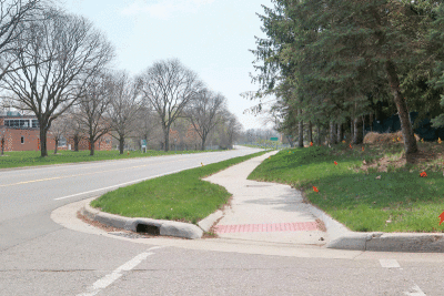
The new shared use path is partially funded by a Transportation Alternatives Program grant.
Photo by Erin Sanchez
BIRMINGHAM — Around the beginning of May, the city of Birmingham is set to start a non-motorized shared-use path project with Cranbrook.
On the west side of Cranbrook Road, a 10-foot-wide shared use path will be constructed from 14 Mile Road to Lincoln Street, and a 5-foot path will be constructed from Lincoln Street to the existing safety path in Bloomfield Township, just south of Middlebury Lane.
On the east side of Cranbrook Road, there will be a 10-foot-wide path from Lincoln to Midvale and a 5-foot-wide path from Northlawn Boulevard to Lincoln Street.
The estimated cost of the project is $1,418,645. It is partially funded by a Transportation Alternatives Program grant, which amounts to $1,116,755.
“This closes one of the areas that is a sidewalk gap where there’s currently not a way to be able to walk or bike in, so it will improve the connectivity of areas that were missing in that location and be able to expand the sidewalks system,” Birmingham City Engineer Melissa Coatta said.
This project will fill several sidewalk gaps in Birmingham, making it easier to walk to areas such as Lincoln Hills Golf Course, the Birmingham Bloomfield Public Arts Center and Ernest W. Seaholm High School.
“Birmingham is known for being a walkable community, and it is hard to be a walkable community if you don’t have a pathway that connects everyone,” Birmingham Department of Public Services Director Scott Zielinski said.
Project background
In 2019, the Road Commission for Oakland County went to the city of Birmingham with their plans to resurface Cranbrook Road in 2020. During this period of time, the city discussed multimodal improvements along Cranbrook, which were outlined in Birmingham’s 2013 multimodal plan.
These multimodal options were presented to the Multi-Modal Transportation Board in 2019, who recommended that the Road Commission pursue certain elements of the plan.
The road resurfacing project was eventually completed by the Road Commission in 2021. This project included re-striping the road between Lincoln Street and Maple Road as a three-lane road rather than a four-lane designation. This allowed for extra space in the roadway and improved bicyclists’ safety.
One element of the project that the Multi-Modal Transportation Board recommended but the Road Commission did not carry out was adding non-motorized improvements along Cranbrook Road, Lincoln Street and 14 Mile Road.
As a separate project, the Multi-Modal Transportation Board recommended pursuing funding through MDOT’s Transportation Alternatives Program. The city was awarded a TAP grant in March 2020.
Following that there were some delays in the design process due to the pandemic and ownership issues. Construction of the shared-use path was also delayed due to other construction projects being pushed back.
Due to these delays, the Southeast Michigan Council of Governments and MDOT shifted the TAP funding for this project to 2022.
At a City Commission meeting May 23, the commission certified that non-federal matching funds had been secured for use in constructing the project, and they approved proposed compensation for temporary and permanent easements required for the project.
Since this approval, the city has been finalizing plans and working out any conflicts before construction starts.
“This project has been a long time coming, and we are happy we are finally able to get it completed, since we’ve got these funds available,” Zielinski said.
 Publication select ▼


