Publication select ▼
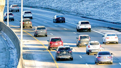
MADISON HEIGHTS — As Hazel Park wraps its “road diet,” Madison Heights is planning one that will shrink a stretch of 11 Mile Road from four lanes to three.
The council approved the plan, 6-1, at its meeting Aug. 12. The “no” vote was Mark Bliss, the city’s mayor pro tem, who expressed concern about the project’s impact on Madison High School and that the board for the Madison District Public Schools wasn’t consulted.
“I’m a big believer that our citizens should have a chance to weigh in, particularly those who are most affected,” Bliss said.
The City Council majority approved the plan because a study said it will reduce congestion and accidents. The project is backed by a nearly $314,000 placemaking grant from Oakland County that is a 60/40 split between the city and county.
The council voted to accept the grant and increase the Downtown Development Authority’s funds to match. An application for the Community Development Block Grant also includes $66,756 for sidewalk improvements.
Work is expected to begin this spring.
How the project started
The larger project runs from Stephenson Highway to Lorenz Street. The first phase is between John R and Lorenz, called the “focus area.”
Plans started with an open house at Woodpile BBQ in October 2023. In April 2024, a plan was completed with a design for four lanes with a median, plus a 6-foot-wide sidewalk on the south side of 11 Mile, and a multiuse path on the north.
The city wanted to fund sidewalks with a state grant through the Transportation Alternative Program. However, TAP wouldn’t cover on-street parking. The sidewalks would also need to be increased to 10-foot-wide multiuse paths to be eligible.
Realizing a four-lane road limited options for TAP funding and that there would be high costs for constructing on-street parking in the right of way, the DDA board requested a plan for three lanes.
This included a traffic study and cost comparison, which was completed June 3.
What the study found
The “road diet” study by Fleis & VandenBrink looked at traffic on 11 Mile from Stephenson Highway to Dequindre Road.
The study found that four lanes without landscaped medians have acceptable operations at all six intersections studied, except for the crossing at 11 Mile and Dequindre where a 180-second signal cycle causes delays at peak periods.
The study also found that if the lanes were reduced from four to three, traffic flow would remain the same at each intersection, except 11 Mile and Dequindre, which at three lanes could experience a three-minute delay in the westbound right-turn lane at peak hours.
The study also projected how three lanes would operate in 20 years, noting there could be delays during peak hours at 11 Mile and Dequindre, and up to four minutes of delay during peak hours at 11 Mile and John R. But it’s expected that travel time won’t change much elsewhere.
To improve flow at 11 Mile and Dequindre, the study recommended reducing the signal time from 180 seconds to 120 and re-striping the westbound approach for a left-turn lane, through lane, and right-turn lane.
Ultimately, the study endorsed three lanes, noting it could reduce crash rates by 15% annually.
Cost comparison
Three lanes for the focus area, with landscaping, would cost about $849,700. By comparison, four lanes would cost nearly $1.14 million.
The benefit of four lanes was beautifying the DDA with landscaped medians while minimizing changes to the existing road. However, modifications for on-street parking and new crosswalks with elaborate signal structures would be necessary.
Three lanes, meanwhile, require less modification for on-street parking, and leave room for amenities like bike racks and benches.
It’s also anticipated that three lanes will improve pedestrian safety because of bumped-out intersections with fewer lanes to cross.
Officials say that three lanes will also have more costs covered by TAP, including items such as curb and gutter costs.
Officials weigh in
Sean Fleming, a member of the council, was optimistic about the plan.
“I actually live in the downtown district, so I travel that way every single day. I feel that this change to three lanes, which includes a left-turn lane, will make it easier to join traffic without waiting so long on the side streets. And that, in turn, should cut down on traffic congestion, and also hopefully reduce the number of motor vehicle accidents,” Fleming said.
“Many of the safety concerns that have been voiced by parents at Madison High School have historically been about the speed of traffic, and drivers having to make dangerous left-hand turns,” Fleming added. “So, having this dedicated left-turn lane should help mitigate the issue.”
Mayor Roslyn Grafstein said progress toward creating a downtown feel has been slow. She said the plan is a step in that direction.
“Personally, I’d rather wait an extra few minutes for safety than have to slow down because of an accident,” Grafstein said. “This safety improvement is especially valuable during busy school hours when more students are crossing the street.”
Mark Kimble, a trustee with the Madison District Public Schools Board of Education, said the board would’ve liked to share input.
“If the City Council thinks that this is a matter of safety for our students, I think the bigger issue is jaywalking. To that end, I think everyone would’ve gotten more bang for their buck with a traffic light near the entry to the high school, rather than shrinking the roads,” Kimble said. “People who jaywalk don’t want to walk down to either corner because it’s a half-mile out of their way. If they had another crosswalk along the way, they would be more likely to use it, and less likely to end up in an accident. The accidents usually happen around Tawas or Wolverine, so a much closer walkway around there could help a lot. I wish the city had consulted us.”
Cindy Holder, the board’s president, said they will review the plan.
“The changes might make the traffic flow a bit more congested in front of the high school heading west, but I’m not sure yet,” Holder said. “The benefit is we have businesses, especially on the north side of 11 Mile, where the parking is kind of obscure between the street and the sidewalk, so I think that’s a safety issue it will address. But as far as the school goes, even a designated left-turn lane to go into the school would’ve been appreciated, but that’s not part of this — everything in this project is going west of the school on 11 Mile to John R. So I guess we’ll just have to wait and see what kind of congestion may be caused by going to three lanes. If it increases the safety of our students and pedestrians, then it will be worth it.”