Publication select ▼
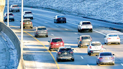
The roundabout at 18 1/2 Mile Road and Van Dyke Avenue has a perennial presence on Michigan Auto Law’s “Most Dangerous Intersections” list.
File photo by Patricia O’Blenes
STERLING HEIGHTS — Some new surveys and an online mapping tool can help eventually make driving, biking or walking safer in Sterling Heights, according to city officials.
The city wants residents and businesses — including drivers, pedestrians, cyclists, mass transit users and more — to visit a new website that has a traffic-related safety survey and more.
According to the city, the public’s help will be instrumental in the creation of an upcoming Sterling Heights Comprehensive Transportation Safety Action Plan, with the aim to stop fatal or serious traffic injuries from occurring.
During a July 2 Sterling Heights City Council meeting, Lia Michaels, from engineering firm Hubbell, Roth & Clark Inc., discussed her firm’s public engagement efforts with the campaign and summarized the traffic safety survey.
“We just ask questions about what mode of transportation people use, how safe they feel the roads are within the city, and notes on various issues that they find,” she said.
Michaels explained that residents can also take a separate Visioning Ryan Road Survey, which asks questions that can help the city improve or re-envision the road’s corridor. Some city officials have previously said the road has been a problem area for speeding.
In addition, the same website that contains both surveys also contains a Safety Mapper Application where residents may pinpoint spots on a map of the city’s roads and make traffic-related observations or air concerns.
“So you can select an area, pick a category of what your observation is related to — whether it be speeding, cut-through traffic, intersection related, pedestrian related — there’s a variety of options to choose from,” Michaels said.
The website will be open for use until the end of August, she said.
In response, Councilman Michael Radtke said he wanted to ensure that the study focuses on multiple modes of transportation, and he asked if the mapping tool will let people mark sidewalks.
“There’s a lot of places that I’m frequently called (about) by residents who are concerned about areas in the city that have sidewalk gaps or are not safe to travel,” Radtke said. “I see you have all the intersections marked, but if you don’t have the sidewalks on your map, and they’re not something that people are commenting on, then you’re directing everyone to improving traffic flow and not actually improving pedestrian safety.”
Michaels said people can make a comment on the map’s roadways closest to the sidewalk issue in question.
Fill out Sterling Heights’ traffic survey by visiting bit.ly/4eADh89, or visit sterlingheights.gov and type “Traffic Calming Survey” in the search bar. For more information, call (586) 446-2489.